
To reach The Statue of Liberty from Mytilini Castle you can either follow the map’s route which will lead you down the main road, or you can take a more scenic route and follow an alternate path through the pine forest. This path can be found on your left as you travel down from the castle back toward the road where you came in from. If you decide to take the pine path then when you reach the end of the woodland pathway, take a right and follow the road till you see The Statue of Liberty by the ferry port.
The Statue of Liberty
The Statue of Liberty
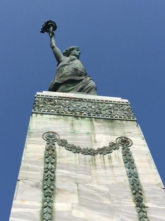
The Statue of Liberty is primarily a memorial of Lesvos’ struggle for independence and final liberation from Ottoman rule in 1912 (Bacas, 2005). However, it also commemorates the losses of many Christian Ottoman Greeks relating to the First World War and Greco-Turkish war periods (1917-1922), including the aftermath of the Asia Minor Catastrophe (ibid.). During WWI, in 1914, the Ottoman government initiated a Greek genocide, with Turkey ethnically cleansing its population of Christian Ottoman Greeks. This continued through the period of the Greco-Turkish War (Jones, 2011). This is considered a crucial factor for Greece’s (late) entry into the First World War in 1917 (ibid.). Therefore Mytilini’s Lady Liberty commemorates all the victims who fell during, and in the aftermath of, Greek independence, as signified by the original inscription regarding the time period of 1912-1922 seen in the picture below on the left.


The memorial was unveiled in 1930, one hundred years after the beginning of an earlier Greek revolution against the Ottomans (Bacas, 2005). Annually on March 25th, the anniversary of this Greek revolution, local authorities lay wreaths at the statue as an act of remembrance for all the lives lost to gain and maintain independence for people (DETAM et al, date unknown). This includes remembering the fallen of the Second World War, when the Italian army followed by the German Nazi forces occupied Lesvos, killing many citizens between 1940-1944 (The European Heritage Project, 2010). This is commemorated by the later addition of a names plaque to the statue as the picture on the right above shows.
The Statue of Liberty lies on a spot where until 1922 stood a rampart or a bastion as part of the Castle (DETAM et al, date unknown). Standing at 15 m high, the monument consists of the bronze statue herself on top of a marble base. The statue was a donation from the island’s expatriate population at the time (1920’s). It was designed by Lesvian artist Georgios Lakovides and inspired by New York’s Statue of Liberty (ibid.). It was sculpted by Gregorios Zevgolis and cast in Germany. It was then sent over to Mytilini via motor boat (Bacas, 2005).
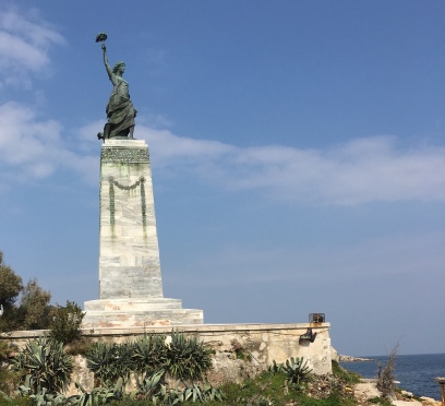
The Statue of Liberty on marble plinth, looking out across the Aegean
The monument is meant to symbolise freedom (Bacas, 2005). Its physical setting, next to the beach of Tsamakia, as well as is positioning – facing out to sea and gesturing with the outstretched arm holding the torch emphasises two symbolic meanings (ibid.). The statue can be interpreted as firstly a positive peaceful statement welcoming people and the prospect of a harmonious future. At the same time, another interpretation is as a solemn acknowledgement of loss; the Greek lives lost in battles, war, persecution and, from a more metaphorical perspective, the loss of the many formerly Greek villages of Asia Minor as she stares longingly toward them across the Aegean Sea.
Refugee Crisis Hot Spots
Recently the Statue of Liberty also looks over one of the biggest political challenges facing Europe. From the statue’s raised platform, there are a couple of places that can be seen which were particularly important sites of the refugee crisis in 2015-16. One was a refugee camp called “No Border Kitchen Camp” set up on Tsamakia Beach (usually a touristic hotspot) by a group of activists to temporarily house and look after the migrants after the first part of their treacherous journey from war-torn Middle-East (see more here). The site can be seen to the left of the Statue if you are facing the sea.
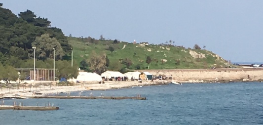
“No Border Kitchen Camp” looking much quieter than in Summer 2015 (Spring 2016)
The other is Mytilini Port seen to the right of the statue if facing the sea. It played a crucial role in the refugees’ passage into Europe since ferries from here would take the migrants to Athens. Migrants would often walk from as far as Molyvos, where they would come in from in the north of Lesvos, for three days to catch a ferry from Mytilini Port.
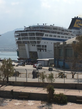
Ferry carrying refugee passengers to Athens from Mytilini just prior to EU-Turkey agreement (Spring 2016)
Both these sites would have been busiest in the summer of 2015 before the weather turned sour in Winter, making it harder to cross, and before the EU deal with Turkey came in, closing off the opportunity to come into Europe without having claimed asylum first (See more here). For now (since April 2016) those who do cross to Lesvos will be catching boats back to Turkey, instead of Athens, from Mytilini.
This event brings us to the social and political turbulence Lesvos is facing today. In light of this modern-day catastrophe, one positive has come through. The Greek Islanders and volunteers, particularly on Lesvos who are at the European front line of the migrant crisis, have been nominated for the Nobel Peace Prize (See more here). Most of Lesvos’ people have been incredibly selfless, pro-active and understanding toward the whole situation; welcoming and helping the refugees who reach their shores. Perhaps, as our historic walk has illuminated, this is partially because past events on Lesvos have shaped a positive perspective toward migrants. As we know, a few even remember what it was like to be the migrants (see Asia Minor Mother).
What is for sure is that Mytilini and Lesvos as a whole has a fascinating socio-political profile. From Ancient Greece to present day, Lesvos has been the centre of much political disruption and activism and also subjected to huge social change.
This completes our tour!
We hope you enjoyed it and you learnt a lot. Though the tour does end here, the map’s path continues. It will take you back to Sappho Square via the port and southern waterfront of Mytilini. Here you can reflect and finally rest your feet at one of the many restaurants, cafes or bars. Thank you for joining us!
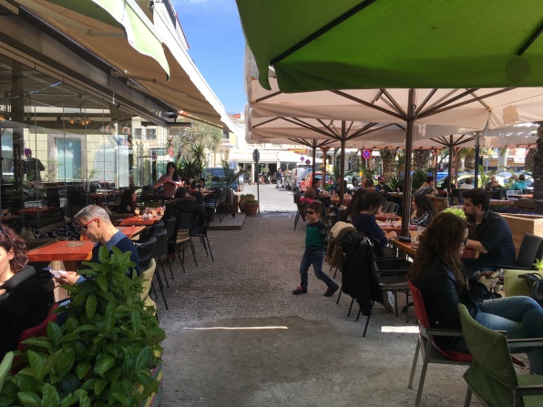
Sappho Square’s Eateries
References
Bacas, J. L. (2005) ‘Mechanisms of boundary construction on the Greek-Turkish maritime border’, in Donnan, H. and Wilson, T.M. (eds.) Culture and power at the edges of the state: National support and subversion in European border regions. Germany: Lit Verlag, pp. 55–80.
DETAM (Mytilini Municipal. Company for the Tourist Development), ETAL (Lesvos Local Development Company, S.A.) and University of Aegean (date unknown) Mytilene e-guide. Available at: http://www.lesvoswalks.net/Mitilini_Guide.pdf (Accessed on: 3 April 2016).
The European Heriatge Project (2010) History of Lesvos. Available at: http://www.european-heritage.org/greece/lesvos/history-lesvos (Accessed: 4 April 2016).
Jones, A. (2011) ‘The Ottoman Destruction of Christian Minorities’, in Genocide: a Comprehensive Introduction. London: Routledge, pp. 149–187.
All Photos Taken by Site Owner, Unless Otherwise Stated in a Caption Under ‘Source’
